Pavel Podvig, “History and the Current Status of the Russian Early-Warning System”, Science and Global Security, Vol. 10 (2002), pp. 21-60
Full version of the article in PDF format (700 kb)
ABSTRACT: The article presents an overview of the history of development and the current status of the Soviet and Russian early-warning system, which was built to provide the Soviet strategic forces with information about a missile attack in an event of a nuclear conflict with the United States. Two main components of this system are considered--the network of early-warning radars and the space-based early-warning system, which includes satellites on highly-elliptical and geosynchronous orbits. The system appears to be capable of detecting a massive attack, but cannot be relied upon to detect individual missile launches.
During the cold war the Soviet Union and the United States not only created massive arsenals of strategic offensive weapons, but also developed and deployed the infrastructure that would provide their offensive forces with the support necessary for implementing various deployment and attack options. One of the most important systems that constituted this infrastructure was a system that would provide early warning of a ballistic missile attack. The United States and the Soviet Union were the only states that deployed early warning systems and gave them prominent roles in their nuclear planning.
The primary mission of an early warning system is to detect a missile attack before the missiles reach their targets. A timely detection of an incoming strike would make it possible to determine the scale of an attack and its origin, estimate potential damage, and choose an appropriate response. An early warning system is absolutely necessary for implementation of a launch-on-warning posture, which assumes that a retaliatory strike would be launched before attacking missiles reach their targets.
Creation of an early warning system that would be capable of fulfilling its mission is a very challenging task. To accomplish its mission, an early warning system must be able to detect a missile as early as possible and provide reliable information about the scale of an attack. Since the system can issue a warning only when an attack is already underway, the time that is available for detection, assessment of the information, and generating an alert is extremely limited.
The short times that are available for detecting an attack and making a decision about an appropriate response call for very tight integration between early-warning and command and control systems. Given the limited time, the procedures for information assessment and decision-making have to be almost automatic. This requires an unprecedented degree of reliability of the early-warning system, since if it generates a false alarm, there might be little or no time to recognize, not to mention to correct, an error.
The important role that early warning systems play in nuclear command and control procedures and the unacceptably high cost of a potential error are the primary reasons why these systems and launch-on-warning strategies they rely on have been receiving so much attention in the recent years. The status of the Russian early warning system is the cause of the most serious concerns, since there are many visible signs of deterioration of that system.
The analysis, presented in this article, of the history of the Russian early warning system and of its current status shows that the system is indeed in decline. In fact, in many cases the decline is much more serious than it may appear. As the analysis shows, the prospects for improvements are not very good and it is likely that Russia will not be able to reconstitute its early warning system.
However, it would be premature to conclude that the dangers associated with the decline of the Russian early-warning capabilities are as grave as its status may imply, since the history of the development of the system shows that the role given to the Russian early warning system in nuclear operations is rather limited.
The main reason for this is that the Soviet Union had never had a complete early-warning system that would be able to detect all possible missile launches. The lack of complete coverage was mainly a result of technical difficulties that the Soviet Union encountered. But partly it reflected the attitude toward early-warning that existed in the Soviet Union, which reveals itself in almost all decisions about the early-warning system made during the Soviet times and in today's Russia.
Although the stated goal of the program was to build an early warning system that would provide comprehensive coverage, the objective at the level of practical decisions seems to be have been more realistic and therefore more limited. The major requirement of the early-warning system was that it had to be able to detect a large-scale attack that could endanger the ability of the Soviet Union (and now Russia) to launch a retaliatory strike. In practical terms, this meant that the system was not required to detect isolated launches or to cover all possible launch areas. In fact, the Soviet/Russian early-warning system has never had this kind of capability.
Since the system was never able to provide warning against all possible threats, the recent loss of early-warning capabilities will not necessarily result in an overall decline of the reliability of the command and control system. Very much depends on the role that early warning plays in the command and control procedures and on the ability of the military to change these procedures to take into account the diminishing quality of early-warning information. Despite the dramatic loss of capabilities, the early warning system is still capable of detecting a massive missile attack, which is its primary mission. The system was never required to detect isolated missile launches and the nuclear command and control system has never relied on this capability. This means that the current decline of the early warning system, which may have led to a loss of this capability, is very unlikely to affect the command and control procedures in a way that would increase risk of an error or misunderstanding.
Early warning system development
The Soviet Union began the development of systems that would provide early detection of a ballistic missile attack in the early 1960s. The first two generations of early-warning radars, deployed in the late 1960s?early 1970s, were modifications of radars that were developed for space-surveillance and antisatellite systems. The primary mission that was most likely assigned to the early warning system was to support missile defenses rather than provide a warning required to achieve a launch-on-warning capability.
The concept of an integrated early-warning system that would include radars as well as satellites and that would be capable of providing the command and control of the strategic forces with the capability necessary for implementing a launch-on-warning option, did not appear until about 1972. This concept was a result of the effort that the Soviet Union undertook in the early 1970s in an attempt to streamline all its programs in the areas of missile defense, anti-satellite warfare, space-surveillance, and early-warning.[1]
The draft project, prepared in 1972, called for development of an integrated early-warning system that would include above-the-horizon and over-the-horizon radars, as well as early warning satellites. The early warning satellites and over-the-horizon radars were supposed to detect launches of ballistic missiles during boost phase of their flight, i.e. almost immediately after their launch. The satellites rely on infrared sensors that can directly detect radiation emitted by the missile plume. An over-the-horizon (OTH) radar, like all radars, detects reflections of electromagnetic signal that it sends in the direction of a target. OTH radars deployed on the Soviet territory were able to detect missile launches on the territory of the United States by using reflections of electromagnetic impulses from Earth?s ionosphere.
The project also called for deployment of a network of early-warning above-the-horizon radars that were supposed to detect incoming missiles and warheads as they approach their targets on the Soviet territory. The radars were intended to provide an important second layer of early warning sensors, which were based on physical principles different from those deployed on satellites. Besides, radars could provide more accurate than satellites information about trajectory of incoming missiles, which allows estimates of scale of an attack.
Another important role that was assigned to the early-warning radars was space-surveillance. The project called for close integration of all existing and future radar facilities that would provide the capability to track objects in outer space and determine parameters of their orbits.
The subsequent development of the early-warning system went largely according to the plan developed in the 1970s. The Soviet Union deployed all three components of the system?satellites and both types of radars. Of these three, the over-the-horizon radars failed to live up to their expectations and did not play any significant role in the early-warning system operations. The satellite and radar deployment programs were more successful and eventually provided the capability they were designed for. However, as shown later in the article, both programs experienced considerable delays during their implementation and suffered serious setbacks at the time of the breakup of the Soviet Union. As a result, the current system is very far from the comprehensive integrated multi-layered early-warning system envisaged by the original plan.
Early warning radars
History of development
The Soviet Union began construction of its first early warning radars in 1963?1964. The first early warning system consisted of two Dnestr-M (Hen House) radars, built at sites in Olenegorsk, Kola Peninsula, and Skrunda, Latvia, and a command center near Moscow. The construction was completed in 1968?1969, and in August 1970 the system was accepted for service.[2] The configuration of the first early warning system strongly suggests that its primary mission was limited to detecting ballistic missiles launched from U.S. territory or sea-based missile launched from the Norwegian Sea and North Sea. It is likely that the main mission of the radars in Olenegorsk and Skrunda was to provide the Moscow missile defense system with early warning information.[3] Figure 1 shows the coverage that was provided by the first two Dnestr-M radars when they became operational as well as the coverage provided by the radars of the Moscow ABM system.
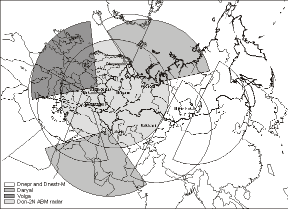
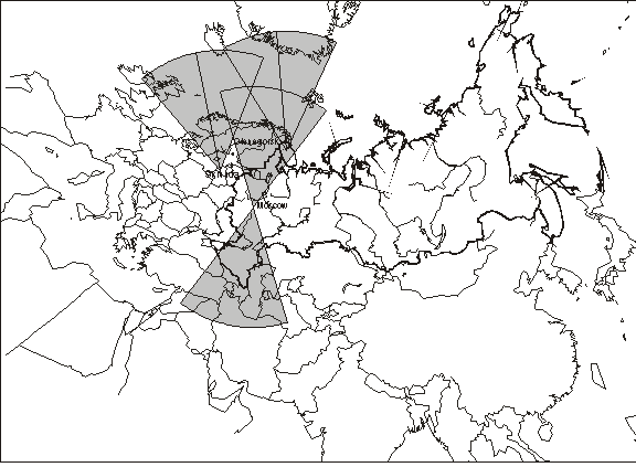
Figure 1. Early warning and missile defense radars in 1972.
In 1967?1968, in parallel with construction of the Olenegorsk-Skrunda system, the Soviet Union began deployment of four additional Dnepr early warning radars. These radars, which were modification of the Dnestr-type radars, are known in the West by the same designation?Hen House. Two of these radars were located at the sites in Balkhash, Kazakhstan, and Mishelevka, near Irkutsk, which had Dnestr space-surveillance radars deployed there.[4] One radar was built at the Skrunda site, next to the Dnestr-M radar, and one?at a new site in Sevastopol.[5]
| Radar | Western designation | Type | Wave-length range | Number of antenna faces, their size and azimuthal sector covered by one face | Main features |
| Dnestr | Hen House | Phased array | 1.5?2 m | 2 faces | Space-surveillance radar |
| Dnestr-M | Hen House | Phased array | 1.5?2 m | 2 faces | Early-warning radar. Dnestr-M is a modification of the space-surveillance Dnestr radar. |
| Dnepr | Hen House | Phased array | 1.5?2 m | 2 faces, | Early-warning radar. Modification of the Dnestr/Dnestr-M design. Some Dnepr radars use Dnestr and Dnestr-M buildings. |
| Daugava | Pechora | Phased array | 1.5?2 m | Transmitter, | A prototype transmitter station for Daryal radars |
| Daryal, | Pechora | Phased array | 1.5?2 m | Transmitter 30x40 m and receiver 80x80 m separated by 0.5?1.5 km, | Early-warning radar |
| Dunay-3 | Dog House | Continuous-wave phased array | ~0.1 m | Transmitter and receiver separated by 2.4 km, ~45 degrees | The radar was built as part of the A-35 Moscow ABM system. Two radars are deployed back-to-back at one site. |
| Dunay-3U | Cat House | Continuous-wave phased array | ~0.1 m | Transmitter and receiver separated by 2.8 km, 51 degrees | The radar was built as part of the A-35 Moscow ABM system. Two radars are deployed back-to-back at one site. |
| Volga |
| Continuous-wave phased array | ~0.1 m | Transmitter and receiver separated by 3 km, | Early-warning radar |
| Don-2N | Pill Box | Phased array | ~0.01 m | 4 faces, receiver antenna 16 m in diameter and transmitter antenna 10x10 m, 90 degrees | The radar is the battle-management radar of the A-135 Moscow ABM system |
Table 1. Main characteristics of Russian early-warning, space-surveillance, and ABM radars.
The four new radars were intended to increase the coverage provided by the network of early warning radars to include North Atlantic, areas in Pacific and Indian oceans, as well as the eastern Mediterranean Sea (see Figure 2). The radars seem to have been built as part of some system, but there is very little information about the exact configuration of that system or about how it was supposed to be integrated into the command and control of nuclear forces. It is possible that these radars were intended to support operations of missile defense systems that the Soviet Union considered deploying.[6]
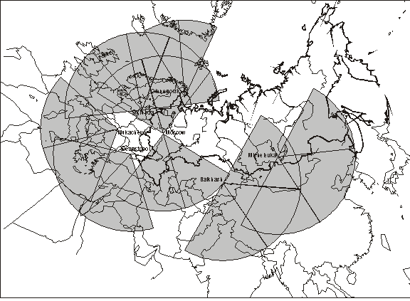
Figure 2. Early warning and missile defense radars deployed by 1979.
By 1972 the industry presented a draft design of an integrated early-warning system. Since the new system was intended to be fully integrated with the existing and future Moscow missile defense system, the first step of the program was to include the radars of the A-35 Moscow missile defense system?Dunay-3 (Dog House) in Kubinka and Dunay-3U (Cat House) in Chekhov?into the early warning network.[7] This work began in 1973 and continued until 1978.[8]
In addition to finishing construction of Dnepr radars that were built at sites in Balkhash, Mishelevka, Sevastopol, and Skrunda, the program called for construction of an additional Dnepr radar at a new site in Mukachevo, Ukraine.[9] These Dnepr radars complemented the existing Dnestr-M radars in Olenegorsk and Skrunda and formed the backbone of the new early warning system.[10] The system was brought into operation in two parts. The first part, which consisted of radars in Olenegorsk, Skrunda, Balkhash and Mishelevka, was commissioned for combat duty on 29 October 1976.[11] The second one, which included radars in Sevastopol and Mukachevo, went operational on 16 January 1979.[12] Figure 2 shows radar coverage that was provided by the early warning radars in 1979.
The next stage of the development of the early warning radar network was the effort to deploy large phased-array radars of the Daryal (Pechora) type.[13] An important feature of the new radar was that its receiving (or transmitting) station could use the existing Dnepr transmitting (or, correspondingly, receiving) stations. The first pilot receiver of the Daryal (Pechora) type, also known as Daugava, was built at the site in Olenegorsk, next to the Dnestr-M (Hen House) radar deployed there, which apparently worked as the transmitter.[14] In 1975, based on the experience of Daugava operations at Olenegorsk, the Soviet government ordered construction of two Daryal radars at new sites in Pechora and Gabala, Azerbaijan.[15]
The Daryal (Pechora) type radars in Pechora and Gabala were intended to complement the network of Dnestr-M and Dnepr (Hen House) radars that was still under construction. This network was eventually completed in January 1979, when the radars in Sevastopol and Mukachevo were brought into operation. Soon after that, in September 1979, the Soviet government approved a plan for the next stage of development. This plan called for modernization of the Dnepr radars, completing construction of two Daryal radars in Pechora and Gabala, and construction of a series of new Daryal-type radars.[16] Two radars of the Daryal-U type were to be built at sites in Balkhash and Mishelevka. A Daryal-U radar was to be built at a new site in Yeniseysk, near Krasnoyarsk.[17] At a later stage of the program, two radars of the Daryal-UM type were to be built in Skrunda and Mukachevo.[18] Figure 3 shows the coverage that a system of Daryal radars was supposed to provide.
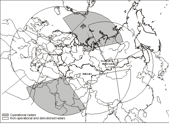
Figure 3. Planned coverage of the Daryal (Pechora) radar network.
The program approved in 1979 also called for construction of a number of Volga radars, which were to provide additional coverage in sectors between those of the Daryal radars.[19] In 1982, construction of the first Volga radar began at a site in Belarus, near Baranovichi.[20] This radar, if completed, would have provided the Soviet Union with an early-warning capability against launches of intermediate-range ballistic missiles based in Europe.[21]
By the mid-1980s, the Soviet Union was carrying out a series of major projects, which, if completed, would have significantly improved its early warning capabilities. In 1984 and 1985, five years behind the schedule, the new Daryal radars in Pechora and Gabala went operational.[22] New Daryal-U radars were under construction in Yeniseysk (Krasnoyarsk), Balkhash, and Mishelevka. Construction of new Daryal-UM radars had begun at sites in Skrunda and Mukachevo. The Volga radar in Baranovichi would have provided coverage of Europe.
These plans, however, never materialized. By the end of the 1980s none of the projects was completed. In addition, work on the radar in Yeniseysk (Krasnoyarsk) had to be suspended after the United States challenged its compliance to the ABM Treaty. In 1989, the Soviet Union admitted violation of the ABM treaty and pledged to demolish the radar.[23] In addition to that, the breakup of the Soviet Union resulted in termination of some of the construction projects and delayed implementation of others. The most significant losses were the new Daryal-UM radars in Skrunda, Latvia and Mukachevo, Ukraine. Work in Mukachevo was suspended in 1991 and has never resumed. The Latvian government, after gaining independence from the Soviet Union, insisted on demolishing the radar buildings in Skrunda, which was done on 4 May 1995.[24] Construction of Daryal-U radars in Mishelevka and Balkhash has not been completed as well.[25]
The only addition to the system that took place in the late 1980s was the Don-2N (Pill Box) radar of the A-135 Moscow missile defense system, located in Pushkino. This large phased-array radar reached full operational capability around 1989 and was integrated into the early warning network. Built as a missile defense battle-management radar, Don-2N can cover all elevation or azimuth angles. The radar in its early warning role replaced the old Dunay-3 and Dunay-3U radars that were part of the first Moscow ABM system.
| Location and radar | Coordinates | Azimuth |
|
| Olenegorsk |
|
|
|
| Dnestr-M/Dnepr | 68.1141N 33.9102E | 323? and 293? |
|
| Daugava | 68.1169N 33.9200E | 308? | Daryal-type transmitter |
| Skrunda |
|
|
|
| Dnestr-M/ Dnepr | 56.7156N 21.9682E | 323? and 293? | The first Dnestr-M, built in 1968. Dismantled in 1998 |
| Dnestr-M/Dnepr | 56.7082N 21.9410E | 8? and 248? | Dismantled in 1998 |
| Daryal-UM | Receiver 56.7242N 21.9761E | 308? | Demolished in1994 |
| Balkhash |
|
|
|
| Dnestr (SKKP) | 46.61N 74.53E | 270? | Space-surveillance |
| Dnestr-M/Dnepr | 46.61N 74.53E | 180? and 124? | Operational in 1972 |
| Dnestr-M/Dnepr | 46.61N 74.53E | 60? | Operational after 1972 |
| Daryal-U | 46.61N 74.53E | 152? (estimate) |
|
| Mishelevka |
|
|
|
| Dnestr (SKKP) | 52.88N 103.28E | 265? | Space-surveillance |
| Dnestr-M/Dnepr | 52.88N 103.28E | 70? and 200? | Operational by 1972 |
| Dnestr-M/Dnepr | 52.88N 103.28E | 135? | Operational after 1972 |
| Daryal-U | Unknown | 135? (estimate) |
|
| Sevastopol |
|
|
|
| Dnepr | 44.5788N 33.3862E | 172? and 230? | Operational after 1972 |
| Mukachevo |
|
|
|
| Dnepr | 48.3777N 22.7042E | 196? and 260? | The last of Dneprs |
| Daryal-UM | Receiver 48.3857N 22.8007E | 218? | Construction stopped in 1991 |
| Pechora |
|
|
|
| Daryal | 65.2N 57.3E | 2? (estimate) |
|
| Gabala |
|
|
|
| Daryal | Receiver 40.8716N 47.8089E | 162? |
|
| Yeniseysk |
|
|
|
| Daryal | 58.1N 92.7E | 40? (estimate) | Dismantled after 1989 |
| Baranovichi |
|
|
|
| Volga | Receiver: 52.8621N 26.4674E | 262.5? |
|
| Kubinka |
|
|
|
| Dunay-3 | Receivers: 55.4796N 36.6482E | 150? and 330? | Dog House |
| Chekhov |
|
|
|
| Dunay-3U | Receivers: 55.2307N 37.2948E | 280? and 100? | Cat House |
| Pushkino |
|
|
|
| Don-2N | 56.1732N 37.7692E | 60?, 150?, 240?, 330? | ABM battle-management radar |
Table 2. Early warning and missile defense radar sites (NOTE: Coordinates of radars and their orientation were determined from satellite imagery, provided by National Imagery and Mapping Agency (NIMA). The imagery is available to the public at geoengine.nima.mil. A collection of images is also presented at www.globalsecurity.org.)
Despite the problems with completing construction of the radars, the radar early warning network that Russia inherited from the Soviet Union was capable of providing adequate coverage of approaches to Russian territory. The only gap in the coverage existed in the northeastern direction that was supposed to be covered by the radar in Yeniseysk (Krasnoyarsk). This gap, however, did not represent a serious problem, since the only U.S. missiles that could exploit this gap were C-4 missiles on Trident I submarines patrolling in the Pacific. These missiles did not have counterforce capability and therefore were a very unlikely weapon for a first disarming or incapacitating strike. The lack of warning from the northwest direction, therefore, did not present a serious risk.
A much more serious problem developed in the northwestern direction. According to an agreement that Russia reached with Latvia in 1994, the Dnestr-M radar in Skrunda, which covered the North Atlantic, ceased operations in August 1998.[26]
The radar in Skrunda occupied a unique position and its loss opened a gap that was not covered by the adjacent radars in Olenegorsk and Sevastopol. The gap to some extent is covered by the Don-2N missile defense radar, located near Moscow. However, because of its location inside Russia, the Don-2N radar provides somewhat shorter warning times.[27] Besides, while the radar in Skrunda was a dedicated early warning radar, Don-2N is supposed to carry other missions, so it may not be able to provide adequate replacement for the dismantled radar.
In an attempt to fill the gap opened by the loss of the radar in Skrunda, Russia renewed its efforts to complete work at the Baranovichi site in Belarus. Construction of the Volga radar at this site, which was all but suspended in the beginning of the 1990s, was resumed in March 1999.[28] Tests of the new radar began in December 1999 and it is expected to reach operational capability in the first half of 2002.[29] However, since the Volga radar was never intended to replace radars in Skrunda, it will not compensate for the loss of the latter completely. Launches of SLBMs from some areas of the North Atlantic could still be detected only by the Don-2N radar in Moscow.

Figure 4. Early warning and missile defense radars in 2002.
The map in the Figure 4 shows the status of the Russian early warning radar network in 2001. The network includes old Dnepr (Hen House) radars located in Olenegorsk and Mishelevka (Russia), Balkhash (Kazakhstan), Sevastopol and Mukachevo (both Ukraine). There are two working Daryal (Pechora) radars?one in Pechora (Russia) and one in Gabala (Azerbaijan). The Volga radar in Baranovichi (Belarus) is undergoing tests and is expected to begin operations in 2002. The Don-2N radar of the Moscow ABM system also seems to take part in the early warning network.
Early warning satellites
According to the project of the early warning system, which was drafted in the beginning of the 1970s, the system was to include a space-based component in addition to the network of above-the-horizon and over-the-horizon radars. Satellites were necessary to extend the capabilities of the early warning system, for they were capable of detecting ballistic missiles almost immediately after launch.
Initially, work on the space-based component of the early warning system was assigned to design bureau headed by A. I. Savin. In 1973, this design bureau was reorganized into the TsNII Kometa (Central Scientific Research Institute Kometa), which became the primary developer of the space-based component of the early warning system.[30] Development of spacecraft platform was assigned to the S. A. Lavochkin Design Bureau.
According to the design developed at TsNII Kometa, the space-based early warning system, known as ?Oko? or US-KS, included a constellation of satellites deployed on highly elliptical orbits and a command and control center near Moscow. The satellites were equipped with infrared and visible-spectrum sensors capable of detecting a burning missile motor against a background of space (but not against a background of Earth surface). The system began limited operations in 1978 and was placed on combat duty in 1982.[31]
As the work on the US-KS (Oko) system progressed, the military produced a set of requirements for a new space-based system, designated US-KMO (in the West this system usually referred to, somewhat incorrectly, as Prognoz). This system was to provide coverage of possible SLBM launch areas from oceans, as well as from U.S. and Chinese territory. In order to do so, the satellites had to have a so-called look-down capability, which is an ability to detect missile launches against a background of Earth surface. Development of the US-KMO system was ordered by a Central Committee and the Council of Ministers decree of 3 September 1979.[32]
Work on the new system, however, was delayed by problems with the old one. The Oko program was plagued by spacecraft malfunctions and software problems.[33] Although the system was able to begin operations in 1982, the problems continued after that. In 1983 the system almost generated a serious false alarm, which was later attributed to problems with the software being unable to cope with sun reflections properly.[34] The satellites continued to suffer from explosive disintegration until 1984.
| Satellite | Type | NORAD number | International designation | Launch date (DD.MM.YY) | Launch time (UTC) | Orbital plane or GEO station | Estimated end of life DDMMYY | Comment |
| Cosmos-520 | HEO | 6192 | 1972-072A | 19.09.72 | 19:19:03 | 4 | Unknown | |
| Cosmos-606 | HEO | 6916 | 1973-084A | 02.11.73 | 13:01:56 | 4 | 30.04.74 | |
| Cosmos-665 | HEO | 7352 | 1974-050A | 29.06.74 | 15:59:58 | 2 | 07.09.75 | |
| Cosmos-706 | HEO | 7625 | 1975-007A | 30.01.75 | 15:02:00 | 7 | 20.11.75 | |
| Cosmos-775 | GEO | 8357 | 1975-097A | 08.10.75 | 00:30:00 | na | Unknown | Orbit was not stabilized |
| Cosmos-862 | HEO | 9495 | 1976-105A | 22.10.76 | 09:12:00 | 5 | 15.03.77 | Self-destructed |
| Cosmos-903 | HEO | 9911 | 1977-027A | 11.04.77 | 01:38:00 | 7 | 08.06.78 | Self-destructed |
| Cosmos-917 | HEO | 10059 | 1977-047A | 16.06.77 | 04:58:00 | 9 | 30.03.79 | Self-destructed |
| Cosmos-931 | HEO | 10150 | 1977-068A | 20.07.77 | 04:44:00 | 2 | 24.10.77 | Failed to reach the working orbit. Self-destructed |
| Cosmos-1024 | HEO | 10970 | 1978-066A | 28.06.78 | 02:58:00 | 2 | 24.05.80 | Moved off station in October 1979 |
| Cosmos-1030 | HEO | 11015 | 1978-083A | 06.09.78 | 03:04:00 | 4 | 10.10.78 | Self-destructed. Orbit was not stabilized |
| Cosmos-1109 | HEO | 11417 | 1979-058A | 27.06.79 | 18:11:00 | 9 | 15.02.80 | Self-destructed. Orbit was not stabilized |
| Cosmos-1124 | HEO | 11509 | 1979-077A | 28.08.79 | 00:17:00 | 4 | 09.09.79 | Self-destructed. Orbit was not stabilized |
| Cosmos-1164 | HEO | 11700 | 1980-013A | 12.02.80 | 00:53:00 | 9 | Launch failure | |
| Cosmos-1172 | HEO | 11758 | 1980-028A | 12.04.80 | 20:18:00 | 9 | 09.04.82 | |
| Cosmos-1188 | HEO | 11844 | 1980-050A | 14.06.80 | 20:52:00 | 2 | 28.10.80 | |
| Cosmos-1191 | HEO | 11871 | 1980-057A | 02.07.80 | 00:54:00 | 4 | 16.05.81 | |
| Cosmos-1217 | HEO | 12032 | 1980-085A | 24.10.80 | 10:53:00 | 2 | 20.03.83 | |
| Cosmos-1223 | HEO | 12078 | 1980-095A | 27.11.80 | 21:37:00 | 7 | 11.08.82 | |
| Cosmos-1247 | HEO | 12303 | 1981-016A | 19.02.81 | 10:00:00 | 5 | 20.10.81 | Self-destructed |
| Cosmos-1261 | HEO | 12376 | 1981-031A | 31.03.81 | 09:40:00 | 6 | 01.05.81 | Self-destructed |
| Cosmos-1278 | HEO | 12547 | 1981-058A | 19.06.81 | 19:37:04 | 4 | 05.07.84 | Self-destructed in December 1986 |
| Cosmos-1285 | HEO | 12627 | 1981-071A | 04.08.81 | 00:13:00 | 6 | 21.11.81 | Failed to reach the working orbit. Self-destructed |
| Cosmos-1317 | HEO | 12933 | 1981-108A | 31.10.81 | 22:54:00 | 9 | 26.01.84 | Self-destructed |
| Cosmos-1341 | HEO | 13080 | 1982-016A | 03.03.82 | 05:44:38 | 5 | 01.02.84 | |
| Cosmos-1348 | HEO | 13124 | 1982-029A | 07.04.82 | 13:42:00 | 9 | 22.07.84 | |
| Cosmos-1367 | HEO | 13205 | 1982-045A | 20.05.82 | 13:09:00 | 1 | 30.09.84 | |
| Cosmos-1382 | HEO | 13295 | 1982-064A | 25.06.82 | 02:28:00 | 7 | 29.09.84 | |
| Cosmos-1409 | HEO | 13585 | 1982-095A | 22.09.82 | 06:23:00 | 2 | 05.01.87 | |
| Cosmos-1456 | HEO | 14034 | 1983-038A | 25.04.83 | 19:34:00 | 4 | 13.08.83 | Self-destructed |
| Cosmos-1481 | HEO | 14182 | 1983-070A | 08.07.83 | 19:21:00 | 6 | 09.07.83 | Failed to reach the working orbit. Self-destructed |
| Cosmos-1518 | HEO | 14587 | 1983-126A | 28.12.83 | 03:48:00 | 5 | 01.06.84 | |
| Cosmos-1541 | HEO | 14790 | 1984-024A | 06.03.84 | 17:10:00 | 3 | 31.10.85 | |
| Cosmos-1546 | GEO | 14867 | 1984-031A | 29.03.84 | 05:53:00 | 1, 4 | 16.11.86 | |
| Cosmos-1547 | HEO | 14884 | 1984-033A | 04.04.84 | 01:40:04 | 7 | 23.08.85 | |
| Cosmos-1569 | HEO | 15027 | 1984-055A | 06.06.84 | 15:34:00 | 5 | 26.01.86 | |
| Cosmos-1581 | HEO | 15095 | 1984-071A | 03.07.84 | 21:31:00 | 8 | 19.08.85 | |
| Cosmos-1586 | HEO | 15147 | 1984-079A | 02.08.84 | 08:38:00 | 4 | 01.04.85 | |
| Cosmos-1596 | HEO | 15267 | 1984-096A | 07.09.84 | 19:13:00 | 9 | 26.11.86 | |
| Cosmos-1604 | HEO | 15350 | 1984-107A | 04.10.84 | 19:49:13 | 1 | 27.09.85 | |
| Cosmos-1629 | GEO | 15574 | 1985-016A | 21.02.85 | 07:57:00 | 4, 3, 1 | 16.01.87 | |
| Cosmos-1658 | HEO | 15808 | 1985-045A | 11.06.85 | 14:27:00 | 6 | 03.09.87 | |
| Cosmos-1661 | HEO | 15827 | 1985-049A | 18.06.85 | 00:40:26 | na | 21.10.89 | Moved off station from the beginning of operations |
| Cosmos-1675 | HEO | 15952 | 1985-071A | 12.08.85 | 15:09:00 | 8 | 18.01.86 | |
| Cosmos-1684 | HEO | 16064 | 1985-084A | 24.09.85 | 01:18:10 | 4 | 09.03.89 | |
| Cosmos-1687 | HEO | 16103 | 1985-088A | 30.09.85 | 19:23:00 | 2 | 30.09.85 | Orbit was not stabilized |
| Cosmos-1698 | HEO | 16183 | 1985-098A | 22.10.85 | 20:24:00 | 3 | 24.08.86 | |
| Cosmos-1701 | HEO | 16235 | 1985-105A | 09.11.85 | 08:25:00 | 8 | 23.11.87 | Moved off station in December 1986 |
| Cosmos-1729 | HEO | 16527 | 1986-011A | 01.02.86 | 18:11:56 | 5 | 14.05.88 | |
| Cosmos-1761 | HEO | 16849 | 1986-050A | 05.07.86 | 01:16:47 | 3 | 23.10.88 | |
| Cosmos-1774 | HEO | 16922 | 1986-065A | 28.08.86 | 08:02:43 | 7 | 17.07.88 | |
| Cosmos-1783 | HEO | 16993 | 1986-075A | 03.10.86 | 13:05:40 | 1 | 03.10.86 | Failed to reach the working orbit |
| Cosmos-1785 | HEO | 17031 | 1986-078A | 15.10.86 | 09:29:18 | 9 | 16.01.91 | Moved off station in December 1989 |
| Cosmos-1793 | HEO | 17134 | 1986-091A | 20.11.86 | 12:09:20 | 2 | 13.08.91 | Moved off station in June 1990 |
| Cosmos-1806 | HEO | 17213 | 1986-098A | 12.12.86 | 18:35:36 | 5 | 20.11.88 | |
| Cosmos-1849 | HEO | 18083 | 1987-048A | 04.06.87 | 18:50:23 | 1 | 20.05.90 | |
| Cosmos-1851 | HEO | 18103 | 1987-050A | 12.06.87 | 07:40:28 | 6 | 23.11.89 | |
| Cosmos-1894 | GEO | 18443 | 1987-091A | 28.10.87 | 15:15:00 | 1 | 22.12.91 | |
| Cosmos-1903 | HEO | 18701 | 1987-105A | 21.12.87 | 22:35:42 | 8 | 11.11.92 | |
| Cosmos-1922 | HEO | 18881 | 1988-013A | 26.02.88 | 09:31:12 | 5 | 30.07.90 | |
| Cosmos-1966 | HEO | 19445 | 1988-076A | 30.08.88 | 14:14:54 | 3 | 14.12.90 | |
| Cosmos-1974 | HEO | 19554 | 1988-092A | 03.10.88 | 22:23:39 | 7 | 20.05.93 | |
| Cosmos-1977 | HEO | 19608 | 1988-096A | 25.10.88 | 18:02:31 | 6 | 12.07.90 | |
| Cosmos-2001 | HEO | 19796 | 1989-011A | 14.02.89 | 04:21:11 | 4 | 15.03.93 | |
| Cosmos-2050 | HEO | 20330 | 1989-091A | 23.11.89 | 20:35:44 | 9 | 08.10.93 | |
| Cosmos-2063 | HEO | 20536 | 1990-026A | 27.03.90 | 16:40:08 | 2 | 21.06.95 | |
| Cosmos-2076 | HEO | 20596 | 1990-040A | 28.04.90 | 11:37:02 | 1 | 30.10.92 | |
| Cosmos-2084 | HEO | 20663 | 1990-055A | 21.06.90 | 20:45:52 | 6 | 21.06.90 | Failed to reach the working orbit |
| Cosmos-2087 | HEO | 20707 | 1990-064A | 25.07.90 | 18:13:56 | 6 | 21.01.92 | |
| Cosmos-2097 | HEO | 20767 | 1990-076A | 28.08.90 | 07:49:13 | 3 | 30.04.95 | |
| Cosmos-2105 | HEO | 20941 | 1990-099A | 20.11.90 | 02:33:14 | 3 | 04.04.93 | Moved off station in February 1992 |
| Cosmos-2133 | GEO | 21111 | 1991-010A | 14.02.91 | 08:31:56 | 4, 3, 2, 1, 4 | 09.11.95 | |
| Cosmos-2155 | GEO | 21702 | 1991-064A | 13.09.91 | 17:51:02 | 1 | 16.06.92 | |
| Cosmos-2176 | HEO | 21847 | 1992-003A | 24.01.92 | 01:18:01 | 6 | 13.04.96 | |
| Cosmos-2196 | HEO | 22017 | 1992-040A | 08.07.92 | 09:53:14 | 5 | 23.06.94 | |
| Cosmos-2209 | GEO | 22112 | 1992-059A | 10.09.92 | 18:01:18 | 1 | 16.11.96 | |
| Cosmos-2217 | HEO | 22189 | 1992-069A | 21.10.92 | 10:21:22 | 8 | 07.11.96 | |
| Cosmos-2222 | HEO | 22238 | 1992-081A | 25.11.92 | 12:18:54 | 1 | 03.12.96 | |
| Cosmos-2224 | GEO | 22269 | 1992-088A | 17.12.92 | 12:45:00 | 2, 1, 2 | 17.06.99 | |
| Cosmos-2232 | HEO | 22321 | 1993-006A | 26.01.93 | 15:55:26 | 4 | 04.06.98 | |
| Cosmos-2241 | HEO | 22594 | 1993-022A | 06.04.93 | 19:07:27 | 7 | 30.01.97 | |
| Cosmos-2261 | HEO | 22741 | 1993-051A | 10.08.93 | 14:53:45 | 9 | 06.03.98 | |
| Cosmos-2282 | GEO | 23168 | 1994-038A | 06.07.94 | 23:58:51 | 1 | 29.12.95 | |
| Cosmos-2286 | HEO | 23194 | 1994-048A | 05.08.94 | 01:12:22 | 5 | 07.03.98 | |
| Cosmos-2312 | HEO | 23584 | 1995-026A | 24.05.95 | 20:10:10 | 2 | 08.12.97 | |
| Cosmos-2340 | HEO | 24761 | 1997-015A | 09.04.97 | 08:58:45 | 8 | 10.05.01 | |
| Cosmos-2342 | HEO | 24800 | 1997-022A | 14.05.97 | 00:33:58 | 6 | 28.10.01 | As of 1.01.2002 |
| Cosmos-2345 | GEO | 24894 | 1997-041A | 14.08.97 | 20:49:14 | 1 | 30.02.99 | |
| Cosmos-2350 | GEO | 25315 | 1998-025A | 29.04.98 | 04:36:54 | 4 | 29.06.98 | |
| Cosmos-2351 | HEO | 25327 | 1998-027A | 07.05.98 | 08:53:22 | 1 | 10.05.01 | |
| Cosmos-2368 | HEO | 26042 | 1999-073A | 27.12.99 | 19:12:44 | 3 | Operational | As of 1.01.2002 |
| Cosmos-2379 | GEO | 26892 | 2001-037A | 24.08.01 | 20:34 | 4, 1 | Operational | As of 1.01.2002 |
| Cosmos-2388 | HEO | 27409 | 2002-017A | 01.04.02 | 22:07 | Failed to reach the working orbit |
Table 3. Early warning satellites.
Deployment of the US-KMO (Prognoz) system did not begin until February 1991, when the Soviet Union launched its first second-generation satellite. The satellite reportedly had genuine look-down capability, which means it could detect missiles against a background of Earth surface. However, the breakup of the Soviet Union slowed down development of the system. Although it was reported that in 1996 the military accepted for service the first tier of the US-KMO system,[35] in 2002 it still remains an essentially experimental program.
First-generation satellites
Spacecraft and ground support systems
A first-generation (Oko) spacecraft consists of three main subsystems: engine block, device compartment, and optical compartment. All the systems are mounted on a cylindrical frame that is 2 m long and has diameter of 1.7 m.[36] Total mass of a satellite at launch is estimated to be 2400 kg, of which 1250 kg is dry mass.[37] The engine compartment of an Oko satellite includes fuel and oxidizer tanks, four orbit correction liquid-fuel engines and 16 orientation and stabilization liquid-fuel engines.[38] The stabilization engines provide active 3-axis attitude control, necessary for telescope orientation.[39]
The telescope system of a first-generation satellite includes a telescope with a mirror of about 50 cm diameter.[40] The detection system includes a linear or matrix infrared-band solid-state sensor that detects radiation from missiles.[41] In addition to this, the satellite has several smaller telescopes that most likely provide a wide-angle view of the Earth in infrared and visible parts of spectrum, which is used by operators of the system as an auxiliary observation channel.[42]
The satellite transmits the images formed by its telescopes directly to the ground control station in real time. The control station facility Serpukhov-15 is located near a village of Kurilovo in the Kaluga region, about 70 km southwest from Moscow. The facility includes antennas that are used for communication with the satellites and the data storage and processing facility.[43] The center was built as a dedicated facility, the only mission of which was to control the early warning satellites.
Launches of early-warning satellites into highly elliptical orbits are performed by Molniya-M launchers from the Plesetsk launch site in the northern Russia. To support the launches, the space forces built a dedicated technical facility at the site and upgraded one of the Molniya launching pads.[44] Launches were performed by space forces crews, but immediately after launch, control over the satellite was transferred to the control station of the Air Defense Forces.[45]
In the beginning of the program, there were serious problems with reliability of the satellites. Of the first 13 satellites, launched in 1972?1979, only seven worked more than 100 days. The satellites were equipped with a self-destruct package that was activated if the satellite lost communication with ground control. Until these packages were removed in 1983, 11 out of 31 satellites were destroyed that way.[46]
As of January 2002, there have been 86 launches of first-generation satellites, 79 of which were launched into highly elliptical orbits. The other seven first-generation satellites were launched into geosynchronous orbit by the Proton launchers. These seven launches, which were conducted from the Baykonur launch site, were all successful.[47]
Of the 79 launches of early warning satellites into highly elliptical orbit, three were launch failures.[48] The other 76 satellites could be divided into three groups, according to their lifetimes. The first group consists of satellites that worked less than one year. This is significantly less than the average lifetime of early warning satellites and indicates that these satellites ended their operation because of a catastrophic failure.[49] This group consists of 21 satellites and includes satellites that were launched during the early days of the program as well as relatively recent ones.
The second group comprises working satellites that were launched before 1985. These satellites worked 20 months on average. The third group consists of satellites that were launched after 1985. The lifetime of these satellites was almost twice as long as that of the satellites in the second group, 40 months on average.
The analysis of the lifetime data strongly indicates that in the mid-80s the designers carried out an upgrade that almost doubled satellite life span. It is likely that the measures that extended the operational life of satellites were included into the program that led to deployment of the first-generation satellites on geosynchronous orbits. The first launch of an operational early warning satellite into the geosynchronous orbit was carried out in 1984. Since the cost of these launches was substantially higher than that of the HEO launches, the program required a longer-living satellite.
Observation geometry
The choice of observation geometry and of the highly elliptical orbits has been usually attributed to the lack of proper infrared sensors and data processing capabilities that are required for obtaining a look-down capability.[50] According to this logic, in the absence of suitable sensors, the Soviet Union had to rely on a the grazing-angle observation geometry, which allowed the use of less sophisticated sensors than those used by the United States.
While the lack of sensors certainly was one of the factors in the choice of the configuration for the first-generation US-KS (Oko) system, other factors seem to have played an equally important role. First of all, the system was apparently not required to provide complete coverage of the Earth surface. Instead, the system was expected to provide much more limited capability of detecting ICBM launches from U.S. territory. Launches of sea-based missiles were deliberately left outside of the system?s scope, since they alone did not pose a serious threat to the Soviet strategic forces. The SLBM threat was not considered significant enough to warrant the efforts required to provide reliable detection of sea-based missile launches.
Then, practical considerations precluded the choice of geostationary satellites. First, a geostationary satellite that would be able to monitor U.S. territory would be out of sight of any ground control station located on the Soviet territory. Unlike the United States, the Soviet Union either was unable to deploy ground relay stations at territories of its allies or was unwilling to do so (or both). Finally, despite the fact that the HEO constellation required more satellites that a GEO one, the GEO satellites would have been less cost-effective, since the early Soviet early-warning satellites had very short nominal lifetimes (about two years on average). Launching short-lived satellites on geosynchronous orbit would have been more expensive than placing them onto HEO orbits.
The system was configured in such a way that a satellite would be placed into an orbit that had inclination of about 63 degrees. The orbits have apogees of about 39,700 km and perigees of about 600 km. A satellite on this orbit has orbital period of approximately 718 minutes, and makes exactly two revolutions a day.[51]
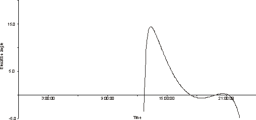
Figure 5. Elevation angle at which a satellite on highly-elliptical orbit is seen from U.S. ICBM bases when it passes the working apogee of the orbit. The satellite can detect a missile against a background of space if the elevation angle is less than about 12 degrees.
Figure 5 shows the change of the elevation angle at which a satellite is seen from a burnout point of a Minuteman missile trajectory. The satellite can see the missile exhaust plum against the background of space if this angle is less than about 12 degrees. As can be seen from the figure, this means that a satellite is in a position to detect a missile launch for about 6 hours every day.[52]
Station-keeping
The ability of a satellite to maintain favorable observation geometry depends on the synchronization between its orbital movement and rotation of the Earth. To keep its orbit within operational limits, a satellite must perform regular station-keeping maneuvers. The HEO early warning satellites use station-keeping procedures that cleverly take advantage of the unique character of perturbations that affect their orbits. For highly elliptical orbits of the kind used by the early warning satellites, the main cause of the drift are perturbations caused by non-spherical shape of the Earth.[53] If uncompensated, these would cause satellite?s groundtrack (measured as a drift of the longitude of the ascending node of the orbit)[54] to drift westward at a rate of about 0.13 degrees/day. However, early warning satellites are placed into orbits on which they initially have an orbital period of about 717.5 minutes, which is slightly less than 718 minutes required for the satellite to make exactly two revolutions a day (which would keep the groundtrack constant). This difference results in an eastward drift of the ascending node of the groundtrack at a rate of about 0.25 degrees a day. These two trends combined result in eastward drift with a rate of about 0.12 degrees a day.
The subsequent character of the orbit?s evolution is determined by other perturbations, which result in a slow decrease of orbital period of the satellite at a rate of about 0.008 minutes a day. The decreasing orbital period slows the eastward drift. When the period reaches 717.75 minutes, the drift reverses its direction. Westward drift quickly accelerates and the ascending node of the orbit soon reaches the longitude from which the cycle started. At this point the satellite performs a maneuver, which decreases its orbital period back to 717.5 minutes. The whole cycle takes from 70 to 90 days, during which the longitude of the ascending node of the satellite?s orbit stays within a band of about 3?4 degrees.
If a satellite stops performing maneuvers, its orbit drifts off the working station after several months and the satellite loses the ability to detect missile launches from U.S. territory. This means that by looking at the changes in orbital period of a satellite, one can reliably determine its operational status. Figure 6 shows how the orbital period of one of the early warning satellites (Cosmos-2312) has changed during its lifetime. As can bee seen from the figure, the satellite ceased operations in December 1997.
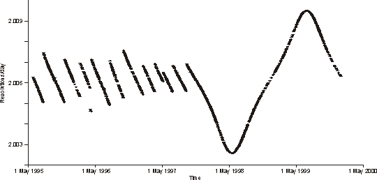
Figure 6. Evolution of mean motion (number of revolutions a day) of Cosmos-2312. To keep parameters of the orbit within operational limits, the satellite regularly performed station-keeping maneuvers. The maneuvers stopped in December 1997, indicating end of operations of the satellite.
The constellation
Since one satellite can be in a position that allows it to detect missile launches only for about six hours a day, providing 24-hour coverage of the U.S. ICBM bases requires at least four working satellites. The system, however, was designed to include up to nine satellites simultaneously. Satellites in the constellation were placed into one of nine orbital planes, which were separated by about 40 degrees from each other. Figure 7 shows the configuration of orbital planes that existed in January 1995.
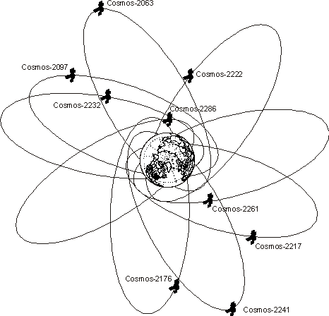
Figure 7. Orientation of orbital planes and relative positions of satellites as existed in January 1995 (view from north).
One reason the system was designed to include satellites in nine separate orbital planes was to increase its reliability and to make sure that a loss of one satellite would not create a gap in coverage. A more important reason, however, was that the chosen configuration made it possible for several satellites to observe the same area simultaneously. The advantage of this is that simultaneous observation is that it reduces the chances that all the satellites that are in a position to detect a launch could be simultaneously blinded by direct sunlight or reflections off clouds.
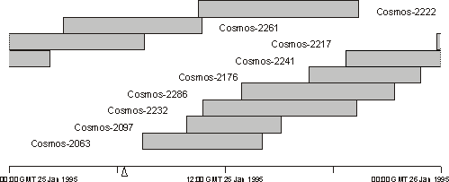
Figure 8. Coverage provided by the constellation of early-warning satellites on highly-elliptical orbits during 25 January 1995. The triangle shows the time of launch of a sounding rocket from the Andoya missile range in Norway, which was detected by the Russian early-warning system.
The system was designed in such a way that at any given moment there is more than one satellite that can detect a launch. Figure 8 shows coverage periods provided by individual satellites. As can be seen from the figure, in a full constellation coverage periods overlap to provide the necessary redundancy. It should be noted that the system does not have to switch between different ICBM bases, since they are all covered simultaneously.
Beginning in 1984, the constellation of HEO early warning satellites was complemented by satellites in geosynchronous orbit. Satellites that were placed into geosynchronous orbit were the same first-generation satellites that were deployed in highly elliptical orbits. A satellite placed into the point with longitude of 24 degrees on geosynchronous orbit would see missile launches from U.S. territory at exactly the same angles as an HEO satellite during the working part of its orbit. In addition, a geosynchronous satellite has the advantage of not changing its position relative to the Earth, so one satellite can provide continuous backup of the HEO constellation.[55]
The introduction of geostationary satellites made the system considerably more robust, for it became much more tolerant to a loss of HEO satellites. As was already discussed, without the GEO satellite the system cannot provide continuous coverage of the U.S. territory with fewer than four satellites. With the GEO satellite present, the system could still detect launches even if there are no HEO satellites deployed. The quality of coverage may suffer and detection may not be reliable enough, but the system would not be completely blind.
History of deployment
The first satellite that was placed into the highly elliptical orbit characteristic of the early-warning satellites was Cosmos-520, launched on 19 September 1972. The exact nature of its mission is unclear, since there are not enough data to see if the satellite performed any maneuvers or orbit corrections, but it was reported to be a success.[56]
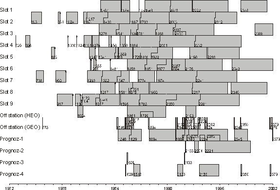
Figure 9. Launches of early-warning satellites and distribution of the satellites among the slots on highly-elliptical and geosynchronous orbits.
In the following three years there were four more launches on highly-elliptical orbits, all of which seem to have been experimental.[57] In addition to this, the Soviet Union conducted an experimental launch of one of the early warning satellites, Cosmos-775, into a geostationary orbit.[58]
Beginning in 1977, the Soviet Union undertook a series of launches that seemed to be an effort to built a working prototype of the early warning system. In contrast with previous launches, which sometimes placed satellites into non-standard orbits, in the series that began in 1977 satellites were placed into orbits that would allow them to work together. The resulting constellation was still experimental, for the satellites were deployed on orbits in such a way that their groundtracks were shifted about 30 degrees westward from the position that will later become nominal. The satellites in those orbits could not detect launches from operational ICBM bases. Most likely they were observing test launches of U.S. missiles from the Vandenberg Air Force base, since they would be able to see them under observation conditions that were very similar to the nominal ones.
Judging by the history of deployment, the prototype system was to include four satellites that would provide the minimum capability, ensuring that at least one satellite was in a position to detect a launch at any given moment. However, because of the series of malfunctions and failures, it was not until 1980 that the number of working satellites reached four.
Despite the fact that the system experienced serious problems and the number of satellites would not exceed two for most of the time, in 1978 the Soviet military accepted the space-based early warning system for limited combat service.[59] In reality, however, until 1981 the system was deployed in experimental configuration, with groundtracks shifted westward.
In the beginning of 1981 Soviet Union began building an operational constellation that would be capable of detecting launches from the U.S. ICBM bases. In order to do so, in February?March 1981 the four satellites that were in orbits at that time performed maneuvers that synchronized their orbital motion in a way that would allow the satellites to observe launches from ICBM bases. Groundtracks of their orbits were moved about 34 degrees eastward and reached position in which the longitude of the ascending node of the orbit was about 55 degrees west. In addition to this, new launches began filling the slots that had not been previously occupied.[60] In February 1981 the number of working satellites reached five for the first time.[61]
The next milestone was achieved in 1982, when after a series of launches in March?June, the number of satellites in the constellation reached seven.[62] This meant that the system was capable of monitoring U.S. ICBM launch areas continuously and for most of the day these areas were monitored by more than one satellite. The system therefore reached operational capability and in 1982 was formally accepted for service and began combat operations.[63]
In 1984 the Soviet Union began the program of deploying early warning satellites in geosynchronous orbit. As discussed above, at that point these were the same first-generation satellites that were deployed in highly-elliptical orbits and that were limited to the grazing-angle observation geometry. Nevertheless, deployment of these satellites in geosynchronous orbit must have significantly increased the overall reliability of the system.
The first operational early-warning satellite in geosynchronous orbit was Cosmos-1546. In May 1984 it reached the point with longitude of 24 degrees west (this point is known as Prognoz-1), from which it was able to detect launches of U.S. ICBMs. Since that time, at least one satellite has been deployed at the Prognoz-1 geostationary point almost all the time, providing support for the HEO constellation.[64]
For several years the military managed to keep seven or more working satellites in the HEO constellation by replacing satellites regularly. It was not until June 1987, however, that the number of working satellites in HEO orbits reached the maximum?nine.[65]. In December that year the system reached its maximum strength?nine HEO satellites complemented by a geostationary satellite.[66]
The system worked in full configuration, with eight or nine satellites in HEO orbits and one geostationary satellite, until 1996. In November 1996 the geostationary satellite that was providing support to the HEO constellation, did not perform a regular station-keeping maneuver.[67] This marked a beginning of the decline of the capabilities of the space-based early warning system that Russia is currently struggling to keep under control. By the end of 1996 the system lost one of its HEO satellites as well.
In 1997 Russia launched two HEO and one GEO satellite in an attempt to replenish the deteriorating system. These launches help to maintain the system for a while at a level of six HEO satellites, but three of them soon ceased operations. As a result, in March 1998 the system included only three HEO satellites in addition to a geostationary one. The HEO constellation was not able to detect missile launches for a significant portion of a day.[68] Although the GEO satellite prevented a complete loss of detection capability, reliability of the system must have significantly degraded.
In another setback, the only geostationary satellite that was providing support to the weakened HEO constellation, Cosmos-2245, stopped operations in March 1999. As a result, the reliability of the space-based early-warning system suffered dramatically. The gap in coverage, during which no satellite was in a position to detect U.S. launched, reached almost five hours a day. For the rest of the day, an ICBM launch could be detected by only one satellite, which was most likely insufficient for reliable detection.
The situation changed only when Cosmos-2368, launched on 27 December 1999, closed the gap in the HEO coverage. The constellation of four satellites created after the launch was able to provide continuous coverage of the U.S. territory. However, since the HEO constellation did not have support of a geostationary satellite and at no time more than one satellite was in a position to observe launches, the quality of that coverage was probably rather poor.
The constellation of four HEO satellites continued to work with no visible attempts to amend it until 10 May 2001, when a fire at the ground control station damaged the system almost beyond repair. The fire destroyed one of the buildings and cables at the Serpukhov-15 control station, which led to a loss of communication with all four satellites in orbit.[69] A few days later the Military Space Forces announced that control over the satellites was restored with the help of other stations.[70] However, all four satellites stopped maneuvering and started drifting off stations, indicating that the control was not fully re-established.
The control station was able to resume operations only on 20 August 2001.[71] About a month later, on 14 September 2001, one of the HEO satellites, Cosmos-2368, began a series of maneuvers that seem to have the goal of placing it back to an operational orbit. Three other satellites, Cosmos-2340, Cosmos-2342, and Cosmos-2351, remain inoperational (although Cosmos-2342 performed a maneuver in October 2001). These satellites are very unlikely to recover, since they have drifted too far off their stations.
In another important development, a new geostationary early warning satellite, Cosmos-2379, was launched on 24 August 2001. The satellites was initially placed into the point at 80 degrees east (point known as Prognoz-4), but was then transferred into the Prognoz-1 point at 24 degrees west, from which it can provide support to the HEO satellites.[72] On 1 April 2002, after the launch of Cosmos-2388, the number of HEO satellites reached two.
As a result, in the beginning of 2002, the constellation of early warning satellites in highly elliptical orbits included only two operational first-generation satellites, which were unable to provide uninterrupted coverage of ICBM launches from the territory of the United States. As for launches of sea-based missiles or any launches from outside U.S. ICBM bases, the constellation of first-generation satellites, whether complete or not, was not able (or indeed intended) to detect them. That mission was assigned to satellites of the second-generation system.
Second-generation satellites
Early warning satellites of the second generation were developed as part of the US-KMO (Prognoz) system, which was supposed to complement and then replace the US-KS (Oko) space-based early warning system. Development of the US-KMO system began in 1979.[73] In contrast to the first-generation system, which was designed to detect only launches of ICBMs from bases in U.S. territory, the US-KMO system was designed to provide coverage of SLBM launches from oceans as well.
The most important distinguishing feature of the second-generation satellites was their look-down capability.[74] These satellites were to be deployed in geosynchronous orbits, from which they could provide coverage of most of the oceans. It is likely that these satellites are supposed to replace the US-KS (Oko) first-generation satellites in HEO orbits as well. Deployed in highly elliptical orbits, second-generation satellites could provide coverage of polar regions in addition to the coverage of U.S. territory and the oceans.[75]
Details of the US-KMO (Prognoz) system architecture are unknown, but it seems that the system in its full configuration would include up to seven satellites in geosynchronous orbits and about four satellites in highly elliptical orbits. All satellites are supposed to have the capability of detecting launches of ballistic missiles against background of Earth surface and cloud cover.
In 1981, when the Soviet Union began to work on the US-KMO (Prognoz) system, it registered seven positions for geostationary satellites (and frequencies for their transmitters) with the International Telecommunication Union (ITU). Table 4 lists these points, which are commonly known as Prognoz, and dates of their registration and beginning of operations. The initial application submitted to ITU stated that operations in points Prognoz-1?Prognoz-4 would begin in 1982. Satellites in Prognoz-5?Prognoz-7 points were not expected to begin operations until 1990.
| Geostationary point | Longitude | Declared start of operations | Actual start of operations |
| Prognoz-1 | 24 West | 1 June 1984 | 1 June 1984 |
| Prognoz-2 | 12 East | 20 January 1985 | 27 January 1992 |
| Prognoz-3 | 35 East | 10 April 1985 | 23 May 1985 |
| Prognoz-4 | 80 East | 30 January 1985 | 13 March 1985 |
| Prognoz-5 | 130 East | 1 July 1990 | ? |
| Prognoz-6 | 166 East | 1 July 1990 | ? |
| Prognoz-7 | 159 West | 1 July 1990 | ? |
Table 4. Prognoz points on geostationary orbit.
The difference in the dates of beginning of operations reflected the structure of the planned system. Satellites in points 1 to 4 were intended to provide coverage of the U.S. territory, the Atlantic Ocean, Europe, and probably China. These satellites could use the already existing control and communication facilities in Serpukhov-15. Satellites in points 5 to 7, which would provide coverage of the Pacific Ocean, would not be able to communicate with the control station in the Moscow area. Deployment of satellites in these points therefore requires construction of a new control station in the Far East. Until this station was built no satellites could be placed in points Prognoz-5?Prognoz-7. For a number of reasons, construction of the eastern control center was not given a high priority. It was reported to be completed in 1998,[76] but to this day no satellites have been deployed in the eastern Prognoz points.
It is difficult to determine whether a specific satellite in geosynchronous orbit is a first-generation US-KS (Oko) or a second-generation US-KMO (Prognoz) satellite. It is believed that the first second-generation satellite was Cosmos-2133, launched on 14 February 1991.[77] Other satellites that are considered to be second-generation early-warning satellites are Cosmos-2209 (10 September 1992), Cosmos-2224 (17 December 1992), Cosmos-2282 (6 July 1994), Cosmos-2350 (25 April 1998), and Cosmos-2379 (24 August 2001).
The number of satellites that are believed to be second-generation early warning satellites is too low to draw any conclusions about their operational lives. The longest-living second-generation satellite, Cosmos-2224, was operational for 77 months, setting a longevity record for all early warning satellites.[78] Cosmos-2133 worked for 56 months and Cosmos-2209?for 50 months, which probably mean that their operations were successful. Cosmos-2282 ceased operations after 17 months, most likely because of a malfunction. Cosmos-2350 ceased all maneuvers only after two months of work, which also indicates a failure. Cosmos-2379, launched in August 2001, continues to work.
The history of deployment of the US-KMO satellites suggests that the program is still in the development phase. It was reported that in 1996 ?the first echelon of the system of detection of sea-based missiles? was accepted for service.[79] At that time there were two operational second-generation satellites: Cosmos-2209 at the Prognoz-1 point and Cosmos-2224 in the Prognoz-2 point. These satellites, indeed, were capable of detecting SLBM launches in the Atlantic Ocean. However, Cosmos-2209 stopped operations in November 1996 and Cosmos-2224?in June 1999. Since neither of the satellites has been replaced, the coverage of the Atlantic that they provided was lost.
The only second-generation satellite that was operational in the beginning of 2002, Cosmos-2379, was placed into the Prognoz-1 point. Located at this point, the satellite can support the first-generation satellites in highly elliptical orbits and provide limited coverage of the Atlantic Ocean.
Current status of the early-warning system
In 2001 the Russian early warning system probably reached its nadir. The loss of the radar in Skrunda opened a serious gap in the coverage provided by the radar network. The gap was supposed to be closed by the radar in Baranovichi, but the beginning of its operation continues to be postponed. Besides, the Russian military admitted that in any event the radar will not be able to operate at full capacity.
The program of deployment of Daryal (Pechora) radars has effectively ground to a halt. Construction of the radar in Mukachevo is very unlikely to be resumed; the prospects for completing radars in Balkhash and Mishelevka remain dim. In addition to this, legal problems has long complicated operation of the Daryal (Pechora) radar in Gabala, Azerbaijan.[80] Similar problems could potentially affect the status of the radars in Balkhash, Kazakhstan.
The Dnepr (Hen House) and Dnestr-M (Hen House) radars, which provide the largest share of the early warning radar coverage, are about 25 years old and will soon reach the end of their operational lives. A loss of these radars would leave Russia without early warning coverage in very important directions.
The space-based early warning system suffered a severe setback in May 2001, when a fire destroyed the ground control station and resulted in a loss of communication with those few satellites that Russia was able to keep in orbit. Although Russia eventually recovered one of the four satellites and managed to launch new ones to support the existing satellites, the system cannot provide reliable detection of missile launches.[81] Given the rate at which Russia was able to launch early-warning satellites in recent years, it may take two or three years to bring the system back to operation.
The problems experienced by the Russian early warning system stem from a combination of factors. The problems caused by the breakup of the Soviet Union were exacerbated by the chronic underfinancing of the military during most of the 1990s. Another important factor was the mismanagement of the system, in particular during 1997?1999, when all early-warning units were subordinated to the Strategic Rocket Forces.[82]
The reorganization of 2001, which placed all early-warning facilities under command of the Military Space Forces, may lead to a recovery of the early warning system. However, the extent to which this would be technically possible is unclear. To provide complete radar coverage, Russia would have to finish construction of Daryal (Pechora) radars and deploy a series of new radars that would replace the aging Dnepr (Hen House) radars in Ukraine and fill the gap created by the loss of radars in Skrunda and Yeniseysk (Krasnoyarsk). Eventually, Russia would have to build radars that would replace the existing ones in Azerbaijan and Kazakhstan. Implementation of this program would require a massive effort that Russia is unlikely to be able to afford.
The situation with the space-based system is somewhat better. The US-KMO (Prognoz) system, which has the capability to provide coverage of most of the areas from which ballistic missiles can be launched, seems to have reached initial operational capability. At the same time, operation of the system would require deployment and maintenance of a constellation of about ten satellites, which may also be outside of Russia?s capabilities.
Overall, the Russian early warning system seems to have reached the point at which it virtually lost its importance as an integral component of the command and control system of nuclear forces. Quality of the information about missile launches that the system can provide and its reliability seem to be so low that it is highly unlikely that this information will ever be used as a basis for a decision to initiate a launch-on-warning strike. The only marginal capability the system seems to provide is detection of a massive missile attack.
It is important to underscore that the Russian military must be very well aware of the current limitations of the system, which has been in decline for a number of years, and must have downgraded the role it plays in the command and control system. This means that a probability that an error that may result from the inadequate performance of the early warning system would result in an irreversible decision (such as missile launch) is virtually nil. Moreover, it is unlikely that Russia will ever be able to restore the capabilities of its early warning system to the point at which it could be relied upon for decisions of this kind and at which it could allow implementation of launch-on-warning posture of its strategic forces.
The real question, however, is not whether Russia can afford rebuilding and maintaining its early-warning system. The most serious questions are why Russia needs to build one and what role the early-warning system should play in the Russian military doctrine. So far, there has been little public debate in Russia on these questions. However, changes in the U.S.-Russian relationships, especially if they result in substantial reductions of strategic nuclear arsenals, will inevitably raise questions about utility of the early-warning system. It is very likely that this would result in serious changes in the current early-warning development programs and, quite possibly, termination of most of them.
[1] The major part of this effort was a reorganization of enterprises of the Ministry of Radio Industry, undertaken in 1970. The reorganization resulted in creation of one large holding, TsNPO Vympel (Central Scientific Production Association Vympel), which included production facilities as well as scientific research institutes and design bureaus.
[2] V. G. Morozov, ?Vsevidashcheye oko Rossii (The all-seeing eyes of Russia),? Nezavisimoye voyennoye obozreniye, 14 April 2000. According to Votintsev, the system did not become fully operational until 1976. See Yu. V. Votintsev, ?Neizvestnyye voiska ischeznuvshei sverkhderzhavy (Unknown forces of the vanished superpower),? Voyenno-istoricheskii zhurnal, No. 10, 1993, p. 33.
[3] Although the early warning radars did provide information to the Moscow ABM system, there were serious problems with compatibility of these two systems. Yu. V. Votintsev, ?Neizvestnyye voiska ischeznuvshei sverkhderzhavy (Unknown forces of the vanished superpower),? Voyenno-istoricheskii zhurnal, No. 10, 1993, p. 34.
[4] There radars, constructed in 1967, were prototype to the Dnestr-M radars. They are also known as Hen House.
[5] Soviet Strategic Defenses, NIE 11-3-71, 25 February 1971, p. 36. It is possible that the radar in Skrunda was a modified Dnestr-M radar, rather than Dnepr.
[6] Until 1967, the Soviet Union was working on a national missile defense system, which used the same technology as the A-35 (Galosh) Moscow missile defense (Russian Strategic Nuclear Forces, Pavel Podvig, ed. (MIT Press, 2001) p. 419). Later, in 1968?1970, there were several projects of missile defenses that would protect missile deployment areas (V. F. Utkin, Yu. A. Moszhorin, ?Raketnoye i kosmicheskoye vooruzheniye (Missiles and space weapons),? in Sovetskaya voyennaya moshch ot Stalina do Gorbacheva (Soviet military power from Stalin to Gorbachev), Moscow: Voennyi Parad, 1999, pp. 232, 235). The radars may have also intended to be part of the Ekvator early warning system, which was developed in Radio-Technical Institute in 1969. Viktor Sloka, ?50 Years of The Mints Radio-technical Institute,? Military Parade, July-August 1996.
[7] Yu. V. Votintsev, ?Neizvestnyye voiska ischeznuvshei sverkhderzhavy (Unknown forces of the vanished superpower),? Voyenno-istoricheskii zhurnal, No. 10, 1993, p. 34.
[8] This work was completed in 1978, when the Dunay-3U radar became fully operational. Soviet Strategic Defense, NIE 11-3-72, 2 November 1972, p. 19; ?Soviet Forces for Intercontinental Conflict through the Mid-1980s,? NIE 11-3/8-76, p. 41; Oruzhiye Rossii, Katalog (Russian Weapons, Catalog), Vol. IV, Military Parade, 1997, p. 102.
[9] A map of Soviet early-warning facilities in Soviet Strategic Defense, NIE 11-3-72, 2 November 1972, p. 19 did not show the Mukachevo site. It appears on a map in ?Soviet Forces for Intercontinental Conflict through the Mid-1980s,? NIE 11-3/8-76, 1976, p. 41.
[10] An additional Dnestr-M radar in Skrunda was under construction at that time.
[11] G. A. Sukhina, V. I. Ivakin, M. G. Dyuryagin, Raketnyi shchit otechestva (Missile shield of the Motherland) (Moscow, TsIPK RVSN, 1999) p. 171.
[12] V. G. Morozov, ?Vsevidashcheye oko Rossii (The all-seeing eyes of Russia),? Nezavisimoye voyennoye obozreniye, 14 April 2000.
[13] The first draft design of a radar of this type was drawn in the late 1960s by a team at the Radio-Technical Institute, which designed Dnestr and Dnepr radars and was responsible for designing an early warning system at that time. See Yu. V. Votintsev, ?Neizvestnyye voiska ischeznuvshei sverkhderzhavy (Unknown forces of the vanished superpower),? Voyenno-istoricheskii zhurnal, No. 10, 1993, p. 35.
[14] The receiver began operations sometime after 1972, but it was not accepted for service until July 1978. V. G. Morozov, ?Vsevidashcheye oko Rossii (The all-seeing eyes of Russia),? Nezavisimoye voyennoye obozreniye, 14 April 2000.
[15] The decree was issued on 14 April 1975. Construction of the first radar?in Pechora?began in September 1975. See V. G. Morozov, ?Vsevidashcheye oko Rossii (The all-seeing eyes of Russia),? Nezavisimoye voyennoye obozreniye, 14 April 2000; Sergey Martynov, ?Sobytiye. Istoriya Daryala prodolzhaetsya (History of Daryal continues),? Krasnaya zvezda, 13 September 2000, p. 2.
[16] An initial plan, drawn in 1976?1977, suggested building Daugava/Daryal-type receivers at sites in Balkhash and Mishelevka and transmitters in Skrunda and Mukachevo. These plans were later modified to include construction of both transmitters and receivers at all Daryal sites. V. G. Morozov, ?Vsevidashcheye oko Rossii (The all-seeing eyes of Russia),? Nezavisimoye voyennoye obozreniye, 14 April 2000.
[17] The decision to build the radar near Krasnoyarsk led to a very well known controversy about its compliance with provisions of the ABM Treaty, which required all new large phased array radars to be deployed along the periphery of national territory and oriented outward (Article VI(a) of the ABM Treaty). The Soviet Union hoped that it could avoid conflict with the ABM Treaty by classifying the new radar as a space-surveillance, rather than as an early-warning one. The ABM Treaty allowed deployment of large phase-array radars within national territory if the radar was used ?for the purposes of tracking objects in outer space? (See Agreed statements to the ABM Treaty, Statement [F]). However, while the Daryal radar in Yeniseysk would certainly have been used for space-surveillance purposes, it was of the same type as early warning Daryal radars in Pechora and Gabala and therefore should have been considered as an early-warning radar.
[18] By 1983 the construction in Balkhash and Mishelevka, as well as in Yeniseysk was in progress. Work at the Skrunda and Mukachevo sites began later. See map in ?Soviet Capabilities for Strategic Nuclear Conflict, 1983-93,? NIE 11-3/8-83, p. 25.
[19] G. A. Sukhina, V. I. Ivakin, M. G. Dyuryagin, Raketnyi shchit otechestva (Missile shield of the Motherland) (Moscow, TsIPK RVSN, 1999) p. 171; Sergey Sokut, ?Zapadnyi strazh (Western guard),? Nezavisimoye voyennoye obozreniye, 20 August 1999, p. 6.
[20] Russian Strategic Nuclear Forces, Pavel Podvig, ed. (MIT Press, 2001) p. 425.
[21] As a temporary measure, the Dunay-3U (Cat House) radar of the Moscow ABM system was upgraded to provide coverage of the territory of West Germany. This work was completed shortly after 1983. Yu. V. Votintsev, ?Neizvestnyye voiska ischeznuvshei sverkhderzhavy (Unknown forces of the vanished superpower),? Voyenno-istoricheskii zhurnal, No. 9, 1993, p. 34.
[22] Yu. V. Votintsev, ?Neizvestnyye voiska ischeznuvshei sverkhderzhavy (Unknown forces of the vanished superpower),? Voyenno-istoricheskii zhurnal, No. 10, 1993, p. 35. Votintsev mentions serious problems with data processing hardware and software.
[23] Thomas Friedman, ?U.S.-Soviet Talks End With Progress on Arms Control,? New York Times, 24 September 1989, p. 1.
[24] Carol J. Williams, ?Despite Kremlin, Latvia Blasting Radar Facility,? Los Angeles Times, 4 May 1995, p. A10.
[25] In 1999 the United States offered its help to Russia in completing the radar in Mishelevka. Michael Gordon, ?U.S. Asks Russia to Alter Treaty for Help on Radar,? New York Times, October 17, 1999, p. 1. The radar at the Balkhash site was not working in 1997 and there were no reports about a change in its status since then. ?Tridtsat let protivostoyaniya (Thirty years of confrontation),? Nezavisimoye voyennoye obozreniye, 17 October 1997, p. 3.
[26] The agreement between Russia and Latvia was signed on 30 April 1994. According to the agreement, the radar had to stop operations no later than 31 August 1998 and be demolished by 29 February 2000. The radar was dismantled ahead of schedule, by October 1999. Yuri Golotyuk, ?Dyra v rossiiskom nebe i latviiskom budgete (A hole in Russian sky and in Latvian budget),? Izvestia, 22 October 1999.
[27] The Don-2N radar would detect a missile launched from the North Atlantic about 2 to 4 minutes later than a radar in Skrunda. This should be compared to the flight time of a missile, which for an SLBM aimed at Moscow could range from 17 to 22 minutes.
[28] Yuri Golotyuk, ?Moskva vse zhe prismotrit za amerikanskimi raketami (Russia will keep an eye on American missiles after all),? Izvestia, 4 August 1999.
[29] Mikhail Getman, ?PRO bez contra (ABM without counterarguments),? Armeiskii sbornik, No. 3, March 2001, p. 13. The radar, however, will not be able to begin operations in full configuration. This may mean that it will be operating at a fraction of its projected capabilities; Sergey Sokut, Rossiya latayet yadernyi shchit (Russia is patching the nuclear shield),? Nezavisimoye voyennoye obozreniye, 4 August 1999, p. 2.
[30] A. I. Savin was appointed the head of the TsNII Kometa and was the General Designer of the space-based early-warning system. Yu. V. Votintsev, ?Neizvestnyye voiska ischeznuvshei sverkhderzhavy (Unknown forces of the vanished superpower),? Voyenno-istoricheskii zhurnal, No. 10, 1993, p. 38.
[31] Yu. V. Votintsev, ?Neizvestnyye voiska ischeznuvshei sverkhderzhavy (Unknown forces of the vanished superpower),? Voyenno-istoricheskii zhurnal, No. 10, 1993, p. 38. It is not clear, however, how the system could be operational in 1978, for during that year there was never more than two working satellites in orbit. Most likely it was the ground command and control center that began operations in 1978.
[32] G. A. Sukhina, V. I. Ivakin, M. G. Dyuryagin, Raketnyi shchit otechestva (Missile shield of the Motherland) (Moscow, TsIPK RVSN, 1999) p. 171.
[33] Yu. V. Votintsev, ?Neizvestnyye voiska ischeznuvshei sverkhderzhavy (Unknown forces of the vanished superpower),? Voyenno-istoricheskii zhurnal, No. 10, 1993, p. 38.
[34] For an analysis of the incident, see Geoffrey Forden, ?Reducing a Common Danger,? Policy Analysis Paper No. 399, CATO Institute, 3 May 2001, pp. 5?6.
[35] V. G. Morozov, ?Vsevidashcheye oko Rossii (The all-seeing eyes of Russia),? Nezavisimoye voyennoye obozreniye, 14 April 2000.
[36] Nicholas Johnson at al., History of On-orbit Satellite Fragmentation, NASA, Lyndon B. Johnson Space Center, July 31, 1998, p. 110.
[37] V. Pavlyuk, ?Rassekrechen voyennyi sputnik (A military satellite is declassified),? Novosti kosmonavtiki, No. 1,2, 1993; Nicholas Johnson at al., History of On-orbit Satellite Fragmentation, NASA, Lyndon B. Johnson Space Center, July 31, 1998, p. 110.
[38] V. Pavlyuk, ?Rassekrechen voyennyi sputnik (A military satellite is declassified),? Novosti kosmonavtiki, No. 1, 1993, pp. 19?21.
[39] Nicholas Johnson at al., History of On-orbit Satellite Fragmentation, NASA, Lyndon B. Johnson Space Center, July 31, 1998, p. 110.
[40] V. Pavlyuk, ?Rassekrechen voyennyi sputnik (A military satellite is declassified),? Novosti kosmonavtiki, No. 2, 1993.
[41] B. Kagan, Soviet ABM Early Warning System (Satellite-Based Project M), Delphic Associates, 1991.
[42] Yu. V. Votintsev, ?Neizvestnyye voiska ischeznuvshei sverkhderzhavy (Unknown forces of the vanished superpower),? Voyenno-istoricheskii zhurnal, No. 10, 1993, p. 38.
[43] M. Tarasenko, ?Zapushchen ISZ Kosmos-2340 (The launch of Cosmos-2340),? Novosti kosmonavtiki, No. 8, 1997.
[44] K. Lantratov, ?Shtrikhi k istorii SPRN (Moments from the history of the EW system),? Novosti kosmonavtiki, No. 2, 2000, p. 48.
[45] After a series of reorganizations, the units that were formerly part of the Air Defense Forces and those that was part of GUKOS, became subordinated to the unified Missile Space Forces in 2001. This, however, did not affect their responsibilities or changed the fact that the tracking and control systems that they operate are incompatible.
[46] Nicholas Johnson at al., History of On-orbit Satellite Fragmentation, NASA, Lyndon B. Johnson Space Center, July 31, 1998, p. 15?17, 110.
[47] This includes the launch of Cosmos-775, which failed to stabilize its orbit, but nevertheless was considered a successful launch. See Voyenno-kosmicheskiye sily (Military Space Forces), Vol. 2, Moscow, Military Space Forces, 1997, cited in K. Lantratov, ?Shtrikhi k istorii SPRN (Moments from the history of the EW system),? Novosti kosmonavtiki, No. 2, 2000, p. 48.
[48] These were Cosmos-1164 (12 February 1980), Cosmos-1783 (3 October 1986), and Cosmos-2084 (21 June 1990).
[49] This group includes eight satellites that failed to stabilize their orbits and therefore are classified as unsuccessful launches: Cosmos-931, Cosmos-1030, Cosmos-1109, Cosmos-1124, Cosmos-1261, Cosmos-1285, Cosmos-1481, and Cosmos-1687.
[50] See, for example, Geoffrey Forden, ?Reducing a Common Danger,? Policy Analysis Paper No. 399, CATO Institute, 3 May 2001.
[51] A siderial day, to be precise. Siderial day is about 4 minutes shorter, than a solar day. To keep its position relative to Earth constant, a satellite should make certain number of revolutions per a siderial day.
[52] For a more detailed discussion of the observation geometry, see Paul Podvig, ?The Operational Status of the Russian Space-Based Early Warning System,? Science & Global Security, 1994, Vol. 4, pp. 363?384.
[53] The perturbations in question are caused by Earth?s second zonal harmonic.
[54] Longitude of the ascending node of an orbit is the longitude of the point at which a satellite crosses Earth?s equatorial plane as it ?ascends? (hence the name) from south to north.
[55] The satellite, however, would be susceptible to blinding effects of direct sunlight and reflections off clouds.
[56] NORAD was able to obtain orbital elements on a regular basis only in the end of December 1972, when the satellite was already non-operational. It is possible that the satellite performed maneuvers during the three months it was not tracked by NORAD. About the success oft he mission, see Voyenno-kosmicheskiye sily (Military Space Forces), Vol. 2 (Moscow: Military Space Forces, 1997) p. 15, quoted in K. Lantratov, ?Shtrikhi k istorii SPRN (Moments from the history of the EW system),? Novosti kosmonavtiki, No. 2, 2000, p. 48.
[57] The last of these satellites, Cosmos-862, was the first early-warning satellite that exploded in orbit. The explosion occurred on 15 March 1977. Nicholas Johnson at al., History of On-orbit Satellite Fragmentation, NASA, Lyndon B. Johnson Space Center, July 31, 1998, p. 110.
[58] The launch was reported a success, although the satellite did not manage to stabilize its position in the geosynchronous orbit. K. Lantratov, ?Shtrikhi k istorii SPRN (Moments from the history of the EW system),? Novosti kosmonavtiki, No. 2, 2000, p. 48.
[59] Yu. V. Votintsev, ?Neizvestnyye voiska ischeznuvshei sverkhderzhavy (Unknown forces of the vanished superpower),? Voyenno-istoricheskii zhurnal, No. 10, 1993, p. 38.
[60] Before 1981, all satellites were deployed in stations 2, 4, 7, and 9 (with the exception of Cosmos-862). Launches of Cosmos-1247 on 19 February 1981 and of Cosmos-1261 on 31 March 1981 were intended to fill stations 5 and 6 respectively. Only Cosmos-1247 reached the working orbit.
[61] This, however, did not last long, since one of those five, Cosmos-1191, self-destruct on 14 May 1981. Nicholas Johnson at al., History of On-orbit Satellite Fragmentation, NASA, Lyndon B. Johnson Space Center, July 31, 1998, p. 154.
[62] Only two slots were left empty?slot 4 and 6.
[63] Yu. V. Votintsev, ?Neizvestnyye voiska ischeznuvshei sverkhderzhavy (Unknown forces of the vanished superpower),? Voyenno-istoricheskii zhurnal, No. 10, 1993, p. 38.
[64] There was no satellite in the Prognoz-1 point since December 1986, when Cosmos-1629 stopped working, till December 1987, when Cosmos-1824, launched on 28 October 1987, reached the point.
[65] This important milestone was achieved after a launch of Cosmos-1849 on 4 June 1987.
[66] This happened after Cosmos-1894, launched on 28 October 1987, reached the Prognoz-1 point in geosynchronous orbit. In addition to this, there were working satellites that were deployed off station. They were most likely used for experimental purposes. The total number of operational satellites was sometimes as high as 12.
[67] It was a second-generation Cosmos-2209, launched on 10 September 1992.
[68] The gap was partially closed after the launch of Cosmos-2351 on 7 May 1998, but soon after that it was restored anew?Cosmos-2232 did not perform a scheduled maneuver in June 1998.
[69] Sergey Topol and Ivan Safronov, ?U Rossii problemy s PRO (Russia has some problems with ABM),? Kommersant-Daily, 11 May 2001.
[70] This seems unlikely, for the early-warning satellites are incompatible with other space systems. K. Lantratov, ?Shtrikhi k istorii SPRN (Moments from the history of the EW system),? Novosti kosmonavtiki, No. 2, 2000, p. 48.
[71] Ivan Safronov, ?Novosti. Raketa-nositel popala v neletnuyu pogodu (News. A launcher did not start because of the weather),? Kommersant-Daily, 25 August 2001, p. 3.
[72] This transfer was completed by 17 December 2001.
[73] G. A. Sukhina, V. I. Ivakin, M. G. Dyuryagin, Raketnyi shchit otechestva (Missile shield of the Motherland) (Moscow, TsIPK RVSN, 1999) p. 171.
[74] Theodore A. Postol, ?The Nuclear Danger from Shortfalls in the Capabilities of Russian Early Warning Satellites,? Presentation at the Lincoln Laboratory, 12 April 1999.
[75] The U.S. early-warning satellite program, which has long relied on geostationary DSP satellites, plans to deploy some of next-generation SBIRS-High satellites in highly-elliptical orbits, specifically to provide coverage of polar regions. ?OSD Approves SBIRS High Restructure, Two-Year Procurement Delay,? Inside the Air Force, 14 December 2001, p. 1.
[76] V. G. Morozov, ?Vsevidashcheye oko Rossii (The all-seeing eyes of Russia),? Nezavisimoye voyennoye obozreniye, 14 April 2000.
[77] See, for example, The Satellite Encyclopedia by Tag?s Broadcasting Services at <http://www.tbs-satellite.com/tse/>. As a rule, satellites of the first generation are deployed in Prognoz-1 point, while second-generation satellites move between different points. The exceptions from this rule are Cosmos-1546 and Cosmos-1629, which visited other Prognoz points, but are still considered to be first generation satellites.
[78] The longest-living first-generation satellite to date was Cosmos-2232, which was operational for 64 months.
[79] V. G. Morozov, ?Vsevidashcheye oko Rossii (The all-seeing eyes of Russia),? Nezavisimoye voyennoye obozreniye, 14 April 2000.
[80] Russia and Azerbaijan signed an agreement that regulates the status of the radar in Gabala only in January 2002. According to the agreement, the property rights to the radar were given to Azerbaijan, which leased the radar to Russia until 2010. Russia agreed to pay $31mln in back pay and will pay $70 mln for the remaining years of the contract. Andrey Rumyantsev, ?Tsena druzhby?101 million dollarov (The price of friendship is $101 mln),? Vesti nedeli, RTR Television broadcast, 27 January 2002.
[81] As of 1 January 2002, Cosmos-2368 had returned to the working orbit and could provide coverage of U.S. ICBM bases for about 6 hours a day. Cosmos-2342 was still off station and could detect missile launches for only about 3 hours a day.
[82] In a clear sign of the problems that the early-warning units experienced after they were subordinated to the Strategic Rocket Forces, in January 1999 the commander of the early-warning army, Gen.-Let. A. Sokolov, and four his deputies submitted their resignations in which they cited irreconcilable differences with the commander-in-chief of the Strategic Rocket Forces. ?Obzor tekushchikh sobytii (Current events),? IMS Consulting, 15 January 1999.